
Discover a detailed review of Ordnance Survey, the ultimate mapping service for outdoor adventures. This blog explores its powerful features, accurate topographic maps, and user-friendly tools that make hiking, cycling, and route planning easier and safer. Whether you’re a beginner or an experienced explorer, Ordnance Survey provides everything you need to navigate confidently and enhance your outdoor experience.
Table of Contents
ToggleWhat is Ordnance Survey?
Brief History of Ordnance Survey
If you’ve ever gone hiking and wished for a map that feels almost “alive” with detail, chances are you’re looking for something like Ordnance Survey. This isn’t just another mapping service—it’s one of the oldest and most trusted mapping organizations in the world. Founded in 1791 in Great Britain, Ordnance Survey began as a military mapping initiative. Back then, its main purpose was to help defend the country against potential invasions. Over time, however, it evolved into a civilian-focused mapping authority, providing incredibly detailed geographical data.
What makes Ordnance Survey unique is its commitment to accuracy. Unlike generic maps that just show roads and landmarks, OS maps go much deeper—literally. They include terrain features, elevation details, footpaths, and even minor landscape elements like stone walls and streams. This level of detail has made it a favorite among hikers, geographers, and outdoor adventurers for decades. Today, it continues to set the gold standard in mapping, blending traditional cartography with cutting-edge digital tools.
Role in Modern Mapping
Fast forward to today, and Ordnance Survey has transformed into a digital powerhouse. While paper maps are still widely used, the organization has embraced technology with open arms. Its digital services now power apps, GPS tools, and even urban planning systems. Governments, businesses, and individuals rely on OS data for everything from navigation to infrastructure development.
For outdoor enthusiasts, this means you get access to maps that are not only highly accurate but also constantly updated. Imagine planning a trek where every trail, slope, and water source is clearly marked—that’s the kind of confidence Ordnance Survey provides. It’s not just a map; it’s like having a knowledgeable guide in your pocket.
Key Features of Ordnance Survey Maps
Detailed Topographic Information
One of the standout features of Ordnance Survey maps is their topographic detail. These maps don’t just tell you where to go—they show you what the land actually looks like. You’ll find contour lines indicating elevation, symbols for different types of terrain, and markings for natural features like rivers, forests, and hills.
This level of detail is especially useful for hikers and trekkers. For example, if you’re planning a route, you can easily identify steep climbs or flat trails. It’s like reading the landscape before you even set foot on it. This makes OS maps incredibly reliable for both beginners and experienced adventurers.
Digital Mapping Tools
Ordnance Survey has stepped into the digital age with powerful mapping tools. Their online platform allows users to create custom routes, measure distances, and analyze terrain—all from the comfort of their home. These tools are intuitive and designed to make planning outdoor adventures easier than ever.
What’s even better is that these digital maps are synced across devices. Start planning your route on your laptop, and continue it on your phone when you’re on the go. It’s seamless, efficient, and incredibly convenient.
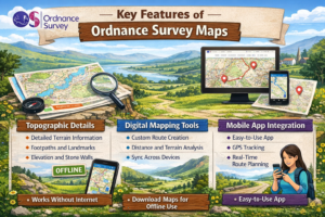
Mobile App Integration
The Ordnance Survey app is where everything comes together. Available on both Android and iOS, the app offers a complete mapping experience. You can access detailed maps, plan routes, and even track your progress in real time.
The app also supports GPS navigation, which means you can use it even in remote areas. And yes, it works offline too—just download the maps beforehand. This feature alone makes it a must-have for anyone heading into areas with limited connectivity.
Types of Ordnance Survey Maps
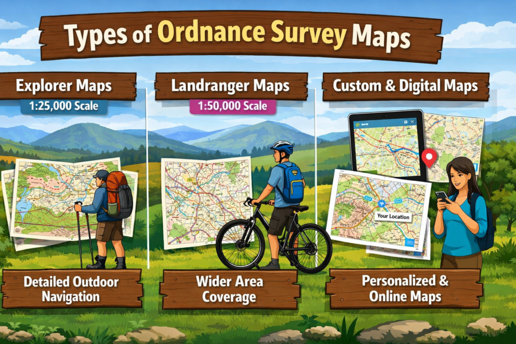
Explorer Maps
Explorer maps are designed for detailed outdoor use. They typically use a 1:25,000 scale, which means every centimeter on the map represents 250 meters in real life. This level of detail is perfect for hiking, as it includes footpaths, bridleways, and even minor trails.
If you’re someone who enjoys exploring off-the-beaten-path locations, Explorer maps are your best friend. They provide the kind of detail that helps you navigate even the most remote areas with confidence.
Landranger Maps
Landranger maps, on the other hand, use a 1:50,000 scale. These are less detailed but cover larger areas, making them ideal for long-distance travel or general navigation. They’re perfect for road trips, cycling, and broader exploration.
Think of Landranger maps as your “big picture” view, while Explorer maps zoom in on the details. Both have their place, depending on your needs.
Custom and Digital Maps
Ordnance Survey also offers custom mapping options. You can create personalized maps based on your specific route or area of interest. This is especially useful for planning unique adventures or events.
Digital maps take this a step further by allowing real-time updates and interactive features. You can overlay different types of data, making your map as detailed or as simple as you like.
Ordnance Survey App Review
User Interface and Experience
The Ordnance Survey app is surprisingly user-friendly. Despite offering a wealth of features, it manages to keep things simple and intuitive. The interface is clean, with easy navigation and clear icons.
Even if you’re not tech-savvy, you’ll find it easy to use. The app guides you through each step, whether you’re planning a route or tracking your journey.
Offline Navigation Features
One of the biggest advantages of the app is its offline capability. Once you download a map, you can use it without an internet connection. This is a game-changer for outdoor adventures, where connectivity is often limited.
Imagine being deep in the mountains with no signal—and still having access to a detailed map. That’s the kind of reliability Ordnance Survey offers.
Route Planning Tools
The route planning feature is another highlight. You can create custom routes, set waypoints, and even estimate travel time. The app also suggests popular routes, which is great if you’re looking for inspiration.
It’s like having a personal guide who knows all the best trails.
Pricing and Subscription Plans
Free vs Premium Features
Feature | Free Version | Premium Version |
Basic Maps | ✔ | ✔ |
Route Planning | Limited | Full Access |
Offline Maps | ❌ | ✔ |
GPS Tracking | ❌ | ✔ |
The free version is decent, but the premium plan unlocks the full potential of the app.
Value for Money
Considering the features, the premium subscription offers excellent value. It’s a small price to pay for safety, convenience, and enhanced adventure planning.
Benefits for Outdoor Enthusiasts
Hiking and Trekking
For hikers, Ordnance Survey is almost indispensable. The detailed maps help you navigate safely, avoid dangerous areas, and discover hidden trails. It’s like having a bird’s-eye view of the terrain.
Cycling and Mountain Biking
Cyclists also benefit from OS maps. They show elevation changes, road types, and off-road trails, making it easier to plan routes that match your skill level.
Camping and Exploration
If you love camping, these maps help you find suitable spots, water sources, and safe routes. They make your adventure more enjoyable and less stressful.
Comparison with Other Mapping Services
Google Maps vs Ordnance Survey
Google Maps is great for urban navigation, but it lacks the detailed terrain data needed for outdoor adventures. Ordnance Survey fills that gap perfectly.
Komoot vs Ordnance Survey
Komoot is excellent for route recommendations, but OS maps offer superior detail and accuracy. Ideally, using both together can give you the best of both worlds.
Pros and Cons of Ordnance Survey
Advantages
- Highly detailed maps
- Reliable and accurate
- Excellent offline functionality
- Great for outdoor activities
Limitations
- Premium features require subscription
- Focus mainly on UK regions
- Slight learning curve for beginners
Who Should Use Ordnance Survey?
If you love outdoor adventures—whether it’s hiking, cycling, or camping—Ordnance Survey is for you. It’s also ideal for professionals who need precise geographical data.
Final Verdict
Ordnance Survey stands out as one of the best mapping services for outdoor enthusiasts. Its combination of detailed maps, powerful digital tools, and reliable performance makes it a top choice.
Conclusion
Choosing the right mapping service can make or break your outdoor adventure. Ordnance Survey doesn’t just help you find your way—it enhances your entire experience. From detailed terrain data to advanced digital tools, it offers everything you need to explore with confidence. Whether you’re a beginner or a seasoned adventurer, this mapping service provides the reliability and precision you can trust. Once you start using it, you’ll wonder how you ever explored without it.
Read Also:
Unlocking Wellness: How Your Super DE is Transforming the Superfood Industry
Tiqets: Your Ultimate Ticketing Platform for Seamless Travel and Attraction Bookings
Weight Watchers Online: Achieve Your Health Goals with Personalized Weight Loss Programs
TicketNetwork: Your Go-To Marketplace for Concert, Sports, and Event Tickets
The Rise of Kontist: Smart Banking Solutions for Modern Professionals
Why Novakid Global ARABIC Is a Game-Changer in Digital Language Education
Frequently asked questions
Yes, it offers a free version, but premium features require a subscription.
Yes, offline maps are available with the premium plan.
No, it primarily focuses on the UK.
Yes, it provides more detailed terrain information.
Yes, the interface is simple and easy to use.